The port authorities and governing classes would meanwhile have been struggling to bring regulation and system to the docks, as the churches strove to inject some much needed moral guidance into the equation.
The docks would have attracted all kinds of characters – criminals, opportunists, entrepreneurs, employment seekers and more, from all around Britain and far further afoot too. Stories of perilous experiences, of far off countries would be exchanged, and exotic goods of various types dispersed and shown off, even, for example, a pair of boa constrictors that could be shown off for a small fee in the local taverns. From sea and from land tumbled in the under-nourished, the ill, the injured, the widowed and orphaned, the street urchins, and gangs all carousing the area in search of easy pickings, gainful employment, or just some kind of means of hope or survival.
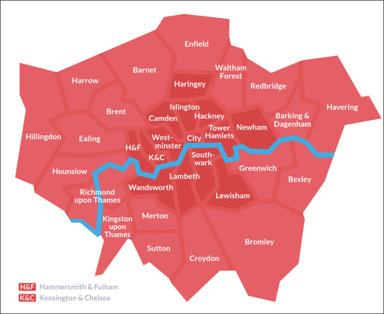
The London Boroughs. Newham was formed out of the old boroughs of West Ham and East Ham. From: http://hidden-london.com/miscellany/london-boroughs-map/
Leaving the docks and heading up Farmer Street, past the birthplace of Charles John Robinson, would have been to walk along a road of seamen and docklanders’ families, a community formed by maritime trade. Farmer Street ran very roughly parallel to New and Old Gravel Lane, and all off these three streets emerged onto the New Ratcliff Highway. Turning left down the Highway would bring you in fairly short order to St. George of the East, birthplace of Harriett Wombwell, and perhaps the location of Richard Wombwell’s chandler’s and grocer’s businesses. A right turn into Betts Street just past St George of the East would be called for you should you wish to do some business with or simply pay a visit to that famous German supplier of wild animals, Mr Charles Jamrach.
Going further north, you would soon reach the Commercial Road, headquarters of George Wombwell’s menagerie emporium, having by then possibly passed by North Street where Harriett and Charles were living in 1841. Further north and to the east lay the parishes of Hoxton, Haggerston, West Ham, Forest Gate, to take just some examples.
London Underground map showing Docklands and The East End
The trend is clear, and was replicated by Richard Wombwell and other dockland families also. When the opportunity arose, move and put some distance between yourself and the docks. And if like, Charles John Robinson, the sea was in your blood, and the docks were your life, the message of your wife was likely to be that you either investigate your ‘stay-over’ options, or learn the meaning of the word ‘commute’.
Thus the East End of London straddled Shadwell, Stepney, Limehouse, Shoreditch, Bow, Bromley-by-Bow, Poplar and Mile End, and the residences of the Robinsons were scattered across both the boroughs of Tower Hamlets and Hackney.


No comments:
Post a Comment
Note: only a member of this blog may post a comment.